

Visual, architectural, and culinary art in every state and major city, mapped by Machine Learning
![]()
![]()
![]()
![]()
![]()
![]()
![]()
![]()
![]()
![]()
![]()
![]()
![]()
Overview
- Journeys
- References (Websites)
- Extreme corners
- Just Touching Each State
- The US Rain Shadow Divide
- US interstate highways
- Refueling and ReCharging
- Taxes
- Coast-to-Coast Trails
- US National Parks
- Civil War Confederates
- Down the Atlantic Eastern Seaboard
- Freedom Ride
- Boston:
- Cambridge (North of Boston):
- Western Mass Turnpike 90:
- Northward Mass up 95:
- SouthEast of Boston on 3 to the tip:
- Western Mass up 91:
- Southern Mass:
- New York City (Manhattan)
- New York City (Brooklyn)
- Philadelphia:
- Pittsburgh:
- Williamsburg:
- Atlanta:
- St. Petersberg Northwest on 75 up the Gulf coast
- South down the East coast
- Miami:
- Down the Mississippi River
- Northward on Cattle Drives
- Journey down the Pan American Highway
- Westward on land
- Westward from Vermont to Kentucky
- Down the Pacific West Coast
- Westward through Northern states
- Westward through the Southwest
- All the sights
- Technical Footnote
This page lists where one can visit, see, and eat near the most significant cultural artifacts in America. I created this page as a “bucket list” so that even if I can’t visit each one and perhaps enjoy on-site, I can still visit their web pages. Someday soon everyone can see treasures from anywhere using VR (Virtual Reality) glasses providing 360-degree views in High Definition.
Do you have a road trip map or story? Share it! I’d love to know.
NOTE: Content here are my personal opinions, and not intended to represent any employer (past or present). “PROTIP:” here highlight information I haven’t seen elsewhere on the internet because it is hard-won, little-know but significant facts based on my personal research and experience.
Journeys
It’s a large country, so cites are listed by each state of the union, along natural geography East-to-West:
Journeys on water as she flows toward the Equator:
- Down the Atlantic Eastern Seaboard (Freedom Ride)
- Down the Mississippi River (on a riverboat?)
- Down the Pacific West Coast
Journeys Northward on Cattle Drives in the 1880s.
Journey South down the Pan American Highway.
Journeys Westward on land (The Pony Express):
- Westward from Vermont to Kentucky
- Westward through Northern states (like Lewis and Clark and on the Oregon Trail)
- Westward through the Southwest (on Route 66)
BTW, finding where each site is located resulted in a great geography and historical lesson for me.
References (Websites)
Since July 4, 1776, the US has grown from 13 colonies with 2.5 million people to 50 states and 14 territories with over 342 million people connected by roughly 5,000 airports, 140,000 miles of train tracks, 4 million miles of roads, and 5.5 million miles of power lines.
- hmdb.org = Historical Marker Database
- movie-locations.com
- Premium screens in the US (Imax, 70mm, etc.)
- locationshub.com/#featured-filming-locations
- 24 UNESCO World Heritage Sites in the United State
- 2,500 National Historic Landmarks in the United States
Extreme corners
Iron Butt motocyle rallies award bonus points for reaching the four corners of the nation:
- NorthWest: Blaine, Washington (where the Peace Arch international monument straddles the border of US and Canada)
- NorthEast: Madawaska, Maine (87% speak French at home in this most northeastern town in the contiguous United States, next to the province of Quebec, Canada)
- SouthEast: Key West, Florida (“Home of the Sunset” where you can see the total lunar eclipse on June 26, 2029 [Wikipedia])
- SouthWest: San Ysidro, California (the busiest border crossing in the Western Hemisphere)
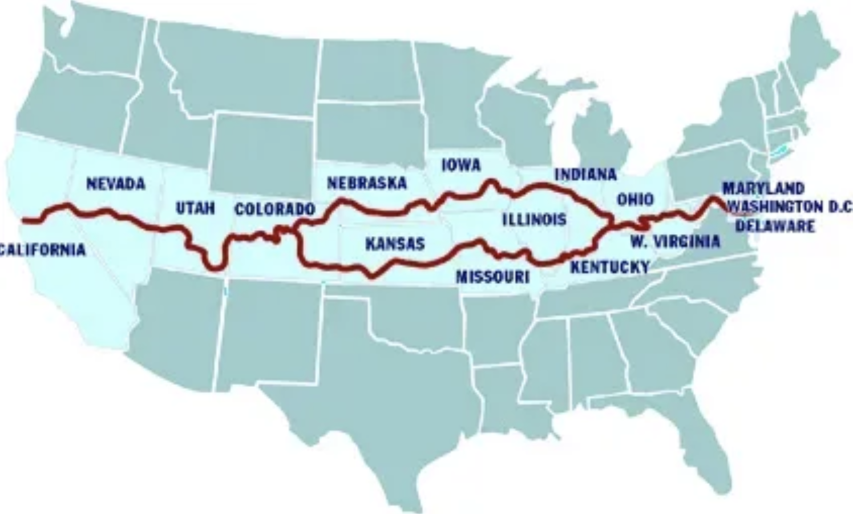
Just Touching Each State
This Google route map was actually used by recent finishers to go around the 48 states in 6 days:
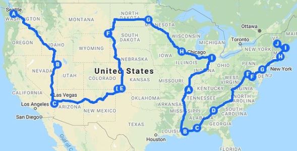
To deter reckless driving among Extreme Road-trippers, the Guinness World Records discontinued listing speed records in 1996. But that didn’t stop the All Fifty States Club website.
The US Rain Shadow Divide
VIDEO: Notice the transition between yellow to green down the middle of the country?
VIDEO: 80% of Americans live East of the (vertical) 98th Meridian, as shown by a green straight line overlaid this map from NASA’s BlackMarble satellite images of the nigh sky worldwide:
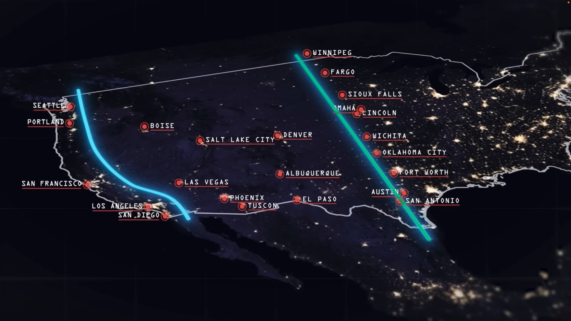
When geologist John Westly Powell identified this phenomenon across the “pairies” in 1890, that natural line was at the 100th Meridian (vs. 98th today). Since then, “Climate change” continues to shift to the East. So expect less rain from Winnapeg (Canada) to Forth Worth, Ausin, and San Antonio Texas. Also impacted will be agriculture around Winnipeg (Manitoba, Canada), Fargo, Sioux Falls, Omaha, Lincoln, Wichita, Oklahoma City.
That green line down the middle of America defines the extent wet storms reach from the East. West of that is the “Rain Shadow” of limited moisture from the Pacific West blocked by the tall Cascade Mountains in Washington state housing Leavenworth, Washington and Rocky Mountains housing Aspen, Vail, Breckenridge, Telluride, Denver, Colorado), Park City, Utah, California.
The East coast also has quaint towns well decorated for Christmas :
- Ogunquit, Maine
- Portsmouth, New Hampshire
- Nantucket, Massachusetts
- Newport, Rhode Island
- Christmas Village, Philadelphia
- Cape May, New Jersey
- Atlantic City, New Jersey
-
New York, New York
- Annapolis, Maryland
- Charlottesville, Virginia
- Lewisburg, West Virginia
- Beaufort, North Carolina
- Myrtle Beach, South Carolina
- Natchitoches, Louisiana
- Santa Rosa Beach, Florida
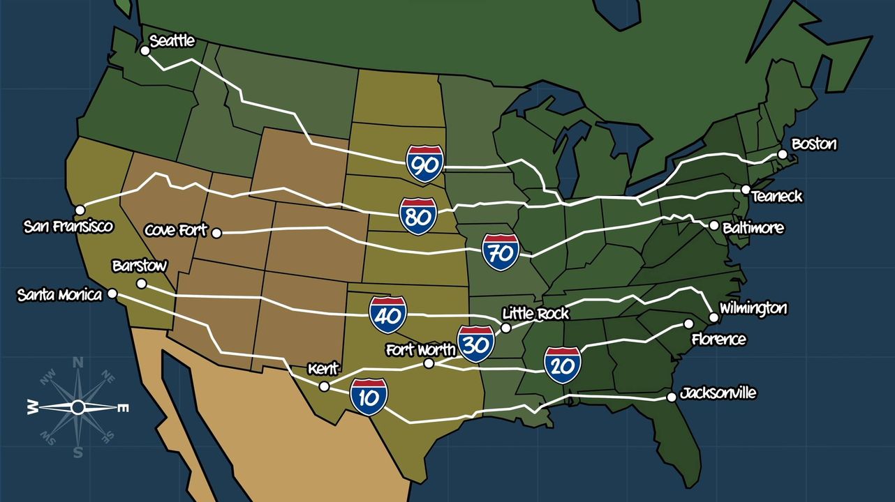
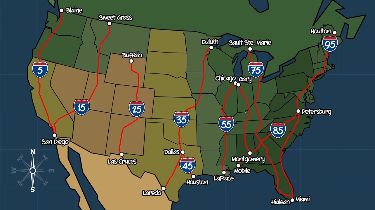
US interstate highways
East-west interstate highway numbers end with 0.
North-South interstate highway numbers end with 5.
Refueling and ReCharging
The number of Tesla Supercharger locations jumped to 2,966 in Q2 2021 from 1,587 at Q1 2019:

In 2023 Ford and GM agreed to enable their electric cars to use Tesla’s charging ports and stations.
A map of stations offering Ethanol-free premium gasoline (at higher prices) is at pure-gas.org/extensions/map.html. My wife used it to figure out where I should stop along a route from Florida to Montana. It was difficult because we had to figure out where I was on the website’s map. She also had to calculate how much further I could go with remaining gas. Somehow we managed to stay married after that.
Taxes
No sales tax is collected from residents within the states of Alaska, Delaware, Montana, New Hampshire, and Oregon. The Sales Tax Institute notes: Residents from other states are often required by laws in their home state to pay out-of-state sales tax. Sellers in tax-free states still collect the sales tax for visitors and remit it to the buyer’s home state if the vendor has a presence in the buyer’s home state. Otherwise, out-of-state buyers are required to pay use tax themselves. Many don’t pay the use tax to their home state even though there can be significant fines, on top of paying the tax, for not doing so.
Some states offer sales tax-free holidays (for a limited time) to encourage spending on products that are considered to be of benefit to the state’s economy. This typically occurs in August and early September for back-to-school supplies, books, computers, and clothing.
Coast-to-Coast Trails
VIDEO: The American Discovery Trail (https://discoverytrail.org/) spans 6,800 miles from coast to coast, with two options in the middle states. The route across rural and urban areas, wilderness, desert mountains and forests.
NERDY TRIVIA: How fast would one need to drive to see a sunset continuously?
If you were at 89.9 degrees North near a Pole, you could walk across all time zones in the world.
The formula is: v = circumference * cos(ϕ) where ϕ = latitude.
At the equator, the circumferance of the earth is 40,075 km, so the earth rotates at
40,075 km / 24 h ≈ 1670 km/h (1038 mph).
At Denver, Colorado, its 40 degrees latitude = 0.77 radians, so 1279 km/h (795 mph).
See my Python program that calculates it at
https://github.com/wilsonmar/python-samples/blob/main/sunset-speed.py
US National Parks
Among America’s greatest treasures are the 63 national parks managed by the U.S. National Park Service.
 The map above is missing White Sands National Park (New Mexico), Indiana Dunes, and Gateway Arch (St. Louis).
One couple visited the most significant parks in this order:


The above route through major landmarks in the lower 48 states was optimized for least driving time across 6,813 miles, using Google Maps API driven by Machine Learning algorithms run in a Python Jupyter Notebook as described by Randal S. Olson. See How to USE AI to Plan a Road Trip.
CAUTION: as COVID lockdowns relax, reservations are at all-time highs at recreation.gov/, KOA, ReserveAmerica.com, and state camping sites.
Many “Western” movies were filmed in iconic “Mighty 5” parks below Salt Lake City in Utah: Las Vegas from the South and Denver from the North  322 miles in 5 hours without stopping (click for Google Map). But you’ll want to stop and marvel the views at each park:
- 4K 360 VIDEO: Zion (Utah’s first National Park)
- 4K 360 VIDEO: Bryce Canyon VIDEO
- 4K 360 VIDEO: Capital Reef
- 4K 360 VIDEO: Arches
- 4K 360 VIDEO: Canyonlands
Civil War Confederates
When the Civil War ended in 1865, The Confederacy included the 11 Southern states of Texas, Arkansas, Louisiana, Tennessee, Mississippi, Alabama, Georgia, Florida, South Carolina, North Carolina, and Virginia.

The 5 “Border States” were Maryland, Delaware, West Virginia, Kentucky, and Missouri (where “brother fought brother”). VIDEO: Although Kentucky’s legislature voted to be neutral, the state was represented as a star in both Confederate and Union flags and was occupied by both Confederate and Union troops. Four times more Kentucky citizens fought for the Union than for the Confederacy.
States in white (Oklahoma) did not fight for either side. Idaho volunteers did not fight against the Confederacy. Areas in Arizona and New Mexico were claimed by both sides.
Down the Atlantic Eastern Seaboard
This is where the United States of America began as colonies of England.
Freedom Ride
The planned route of the courageous Freedom Ride May 1961 through the “Jim Crow” South to test a Supreme Court ruling against “whites-only” restrooms and lunch counters at bus stations:

The Woolworth lunch counter in downtown Greensboro, NC is now a museum.
The ride stopped on May 14 in Anniston, Alabama where their bus was burnt by segregationists.
Maine
- Bates Museum of Art, Lewiston
- Bowdoin College Museum of Art, Brunswick
- Colby College Museum of Art, Waterville
- Farnsworth Art Museum, Rockland
- Hudson Museum at the University of Maine, Orono
- Portland Museum of Art
University of Maine Museum of Art, Orono- Artemus Ward House, Waterford Maine
- Maple syrup creamies!
New Hampshire
- Cornish Colony Gallery and Museum
- Saint-Gaudens National Historic Site, Cornish
- Currier Gallery of Art, Manchester
- Hood Museum of Art, Hanover
- Thorne-Sagendorph Art Gallery at Keene State College
- Robert Frost House, Franconia
Massachusettes
Boston:
Boston is among the safest large cities in the US.
- Arts on the Point Sculpture Park, Boston
- Boston University Art Gallery
- Boston Athenaeum
- Institute of Contemporary Art, Boston
- Isabella Stewart Gardner Museum, Boston
- Museum of Fine Arts
- Museum of Science and Hayden Planetarium
- USS Constitution Museum, Boston
- John F. Kennedy Presidential Library and Museum, Columbia Point, Boston
Cambridge (North of Boston):
- Harvard University Art Museums, Cambridge
- Peabody Museum of Archaeology and Ethnology at Harvard University, Cambridge
- Fogg Art Museum
- MIT Museum
- Arthur M. Sackler Museum
- Rose Art Museum at Brandeis University, Waltham
- Henry Wadsworth Longfellow House, Cambridge, Massachusetts
Western Mass Turnpike 90:
- Edith Wharton's The Mount, Lenox
- Museum of Bad Art, Dedham
- McMullen Museum of Art at Boston College, Chestnut Hill
- Davis Museum and Cultural Center at Wellesley College, in Wellesley, MA
Danforth Museum of Art, Framingham- Worcester Art Museum
- Old Sturbridge Village
- Norman Rockwell Museum, Stockbridge
- Mount Holyoke College Art Museum, South Hadley
- Berkshire Museum, Pittsfield
- Herman Melville's Arrowhead, Pittsfield
- The Springfield Museums at the Quadrangle
- Dr. Seuss Memorial, Springfield
- Site of Thoreau's Cabin, Walden Pond, Concord
- Wayside (home of Nathaniel Hawthorne, Louisa May Alcott, and Margaret Sidney), Concord
- Ralph Waldo Emerson Home, Concord
- Louisa May Alcott's Orchard House, Concord
Northward Mass up 95:
- Griffin Museum of Photography, Winchester
- Tufts University Gallery, Medford
- Whistler House Museum Of Art, Lowell
- Addison Gallery of American Art, Andover
- Peabody Essex Museum, Salem
SouthEast of Boston on 3 to the tip:
- Fuller Craft Museum, Brockton
- The Art Complex Museum, Duxbury
- Plimoth Plantation, Plymouth
- Pilgrim Hall Museum, Plymouth
- Cape Code Museum of Fine Arts, Dennis
- Heritage Museums and Gardens, Sandwich
- Kendall Whaling Museum, New Bedford
- Cahoon Museum of American Art, Cotuit
Western Mass up 91:
- DeCordova Museum and Sculpture Park, Lincoln
- Mead Art Museum at Amherst College, Amherst
- Eric Carle Museum of Picture Book Art, Amherst
- Emily Dickinson's Home, Amherst
- Smith College Museum of Art, Northampton
- Clark Art Institute, Williamstown
- Williams College Museum of Art, Williamstown
- Massachusetts Museum of Contemporary Art, North Adams
Southern Mass:
- Attleboro Museum and Center for the Arts
- New Bedford Art Museum
- Sterling and Francine Clark Art Institute, Williamstown
Rhode Island
- David Winton Bell Gallery at Brown University, Providence
- Rhode Island School of Design Museum of Art Providence
- Newport Art Museum
- National Museum of American Illustration, Newport
Connecticut
- Mercy Gallery at the Loomis Chaffee School, Windsor
- Benton Museum of Art at the University of Connecticut, Storrs
- Mark Twain House and Museum, West Hartford [1]
- Harriet Beecher Stowe Home, West Hartford
- Wadsworth Atheneum, Hartford
- Hill-Stead Museum, Farmington
- New Britain Museum of American Art
- Davison Art Center at Wesleyan University, Middletown
- Florence Griswold Museum, Old Lyme
- Mattatuck Museum, Waterbury
- Slater Museum at Norwich Free Academy
- Yale Center for British Art, New Haven
- Yale University Art Gallery, New Haven
- Housatonic Museum of Art, Bridgeport
- Aldrich Museum of Contemporary Art, Ridgefield
- The Stamford Museum and Nature Center
- Bruce Museum of Arts and Science, Greenwich
New Jersey
- Jersey City Museum across the Hudson from Manhattan
- Newark Museum
- New Jersey State Museum, Trenton
- Jane Voorhees Zimmerli Art Museum at Rutgers University, Brunswick
- Art Museum at Princeton University, Princeton
- Rats [restaurant with gardens]
- Bergen Museum, Hackensack
- Grounds For Sculpture, Hamilton
- Montclair Art Museum
- Morris Museum, Morristown
- Noyes Museum of Art, Oceanville
- Wheaton Village Museum of American Glass, Millville
New York
New York City (Manhattan)
- Bronx Museum of Art
- Metropolitan Museum of Art and the Cloisters
- Alternative Museum
- American Folk Art Museum
- American Museum of Natural History
- Chelsea Art Museum
- Cooper-Hewitt, National Design Museum
- Dahesh Museum
- Dia Center for the Arts
- Dia: Chelsea
- International Center of Photography
- Jewish Museum
- Lehman College Art Gallery
- Morgan Library
- El Museo del Barrio
- Museum for African Art
- Museum of Modern Art (MOMA)
- Museum of the City of New York
- Museum of the National Academy of Design
- National Museum of the American Indian
- Neue Galerie Museum for German and Austrian Art
- New Museum of Contemporary Art
- New-York Historical Society
- Nicholas Roerich Museum
- Queens Museum of Art
- Rubin Museum of Art: Art of the Himalayas
- Staten Island Institute of Arts and Sciences
- Studio Museum in Harlem
- Ukrainian Museum
- Whitney Museum of American Art
- American Museum of Natural History
- Gallery of Modern Art
- GONE: Museum of Holography
- Metropolitan Museum of Art (the Met)
- Guggenheim Museum
- Solomon R. Guggenheim Museum, with Guggenheim.com for motorcycles and Guggenheim.org for environmental art
- Museum of the American Indian
- Grey Art Gallery at New York University
- Frick Collection
- Hispanic Society of America
New York City (Brooklyn)
DUMBO = Down Under the Manhattan Bridge Overpass is home to 25% of New York based tech firms, including Etsy. [tour]
- Walk the Brooklyn Bridge
- River Cafe (Jackets required of men)
- Brooklyn Museum of Art
- Rotunda Gallery
Pennsylvania
- Allentown Art Museum
- Arnold Art Gallery at Lebanon Valley College, Annville
- Barnes Foundation, Merion
- Brandywine River Museum, Chadds Ford
- Charles Demuth Foundation and Museum, Lancaster
- Erie Art Museum, Erie
- Everhart Museum, Scranton
- Glencairn Museum, Bryn Athyn
- James Michener Art Museum, Doylestown
- Juniata College Museum of Art, Huntingdon
- Palmer Museum of Art at Pennsylvania State University, University Park
- Reading Public Museum, Reading
- Samek Art Gallery at Bucknell University, Lewisburg
- Southern Alleghenies Museum of Art, Johnstown
- State Museum of Pennsylvania, Harrisburg
- Widener University Art Gallery and Collection, Chester
- Railroad Museum of Pennsylvania, Ronks (Lancaster)
Philadelphia:
- Franklin Institute Science Museum
- Mütter Museum [weird] 19 S. 22nd St. 19103
- National Liberty Museum
- Pennsylvania Academy of the Fine Arts
- Moore College of Art and Design Galleries
- University of Pennsylvania Museum of Archaeology and Anthropology
- The Eakins Gallery at Thomas Jefferson University
- La Salle University Art Museum
- Institute of Contemporary Art
- Arthur Ross Gallery at the University of Pennsylvania
- Academy of Natural Sciences
- Rosenbach Museum and Library
- Philadelphia Museum of Art
- Rodin Museum at the Philadelphia Museum of Art
- Barnes Foundation Collection, Merion
- Museum of American Art
- University Museum of Archaeology and Anthropology
- Woodmere Art Museum
- Ristorante Pesto
- Vetri Cucina [#50]
- Zahav restaurant of Israeli cuisine, Philadelphia
Pittsburgh:
- Carnegie Museum of Art
- Andy Warhol Museum
- Frick Art and Historical Center
- Mattress Factory Museum of Contemporary Art
- Carnie Museum of Natural History
Delaware
- Biggs Museum of American Art, Dover
- Delaware Art Museum, Wilmington
- University of Delaware Gallery, Newark
- Winterthur Museum, Garden and Library
Maryland
Baltimore had the #3 rate of crime among all cities in the US (2,027/100,000 in 2022).
- Academy Art Museum, Easton
- African Art Museum of Maryland, Columbia
- American Visionary Art Museum, Baltimore
- Art Gallery at the University of Maryland, College Park
- Baltimore Museum of Art
- Contemporary Museum, Baltimore
- Peabody Gallery of Art, Baltimore
- Walters Art Gallery, Baltimore
- Ward Museum of Wildfowl Art, Salisbury
- Washington County Museum of Fine Arts, Hagerstown
Washington DC
- Dumbarton Oaks Collection
- Freer Gallery of Art
- National Air and Space Museum
- National Archives, 700 Pennsylvania Ave. 202-357-5000 See the US Constitution, Bill of Rights and the Declaration of Independence. But the Emancipation Proclamation is open to the public just 4 days a year around MLK Holiday Jan. 13-16 Friday-Monday 10 a.m.-5:30 p.m.
- The Smithsonian Institution: The Freer Gallery of Art and The Arthur M. Sackler Gallery
- Sackler/Freer Galleries
- Art Museum of the Americas
- Corcoran Gallery of Art
- Dimock Gallery at George Washington University
- Dumbarton Oaks Research Library and Collection
- Hillwood Museum and Gardens
- Hirshhorn Museum and Sculpture Garden
- Howard University Gallery of Art
- Kreeger Museum
- U.S. National Gallery of Art
- National Museum of African Art
- Smithsonian American Art Museum
- National Museum of Women in the Arts
- National Portrait Gallery
- National Statuary Hall
- Phillips Collection 1600 21st Street, NW 20009 Closed Mondays
- Smithsonian Institution
- Textile Museum
- U.S. Capital Art Collection
- U.S. Navy Art Collection
- US Holocost Memorial Museum 10-5:30 every day, but timed passes are necessary for visiting the permanent exhibit (20 each day from tickets.com for $1.75)
- White House, 1900 Pennsylvania Avenue
West Virginia
Virginia
Richmond is the capital of Virginia, and the capital of the Confederacy during the Civil War. In 2022 it was the 3rd most dangerous city in the US (2,027/100,000).
- Anderson Gallery at the VCU School for the Arts, Richmond
- Art Museum of Western Virginia, Roanoke
- Belmont, The Gari Melchers Estate and Memorial Gallery, Fredericksburg
- Chrysler Museum, Norfolk
- Hampton University Museum
- Hermitage Foundation Museum, Norfolk
- Lynchburg Fine Arts Center
- Maier Museum of Art at Randolph-Macon Woman's College, Lynchburg
- Museum for American Studies at the University of Virginia, Charlottesville
- University of Virginia Art Museum, Charlottesville
- Sweet Briar College Art Galleries
- University of Richmond Museums
- Virginia Museum of Fine Arts, Richmond
- William King Regional Arts Center, Abingdon
Williamsburg:
- Muscarelle Museum of Art at the College of William and Mary
- Abby Aldrich
- Rockefeller Folk Art Collection
- Colonial Williamsburg Villege reenacts 18th centry American village
North Carolina
- Asheville Art Museum
- Biltmore Estate, the largest privately-owned house in America, built by George Vanderbilt, Asheville
- In Asheville, the fanciest McDonald's in America (with a piano and fireplace)
- Ackland Art Museum at the University of North Carolina, Chapel Hill
- Lantern restaurant, Chapel Hill
- Duke University Museum of Art, Durham
- Guilford College Art Gallery, Greensboro
- Hickory Museum of Art
- Mint Museum of Art, Charlotte
- North Carolina Museum of Art, Raleigh
- Contemporary Art Museum, Raleigh
- North Carolina State University Gallery of Art and Design, Raleigh
- Reynolda House Museum of American Art, Winston-Salem
- Southeastern Center for Contemporary Art (SECCA), Winston-Salem
- Wake Forest University Art Collections, Winston-Salem
South Carolina
- Bob Jones University Museum and Gallery, Greenville
- Greenville County Museum of Art
- Columbia Museum of Art
- South Carolina State Museum, Columbia
- Gibbes Museum of Art, Charleston
- Huntington Sculpture Garden, Pawleys Island
- Spartanburg County Museum of Art
- Fort Sumter National Monument, Sullivan's Island
- FIG restaurant, Charleston
- Husk restaurant (Southern food), Charleston
Georgia
- Albany Museum of Art
- Booth Western Art Museum, Cartersville
- Columbus Museum
- Georgia Museum of Art at the University of Georgia, Athens
Atlanta:
- Carlos Museum at Emory University
- World of Coca Cola
- High Museum of Art
- Oglethorpe University Museum, Atlanta
- Jimmy Carter Presidential Library and Museum, Atlanta
- Staplehouse restaurant (menu)
- Morris Museum of Art, Augusta
- Telfair Museum of Art, Savannah
- The Grey, Savannah
Florida
St. Petersberg Northwest on 75 up the Gulf coast
- John and Mable Ringling Museum of Art, Sarasota
- Fort Myers Edison Winter Home
- Tampa Museum of Art
- University of South Florida Contemporary Art Museum, Tampa
- Bern's Steak House, Tampa
- Florida International Museum, St. Petersburg
- Museum of Fine Arts, St. Petersburg
- Salvador Dalí Museum, St. Petersburg
- Florida State Museum, Gainsville
- Harn Museum at the University of Florida, Gainesville
- Appleton Museum of Art, Ocala
- Mary Brogan Museum of Art and Science, Tallahassee
- Pensacola Museum of Art
- Florida State University Museum of Fine Arts, Tallahassee
- NASA Kennedy Center, Merritt Island
South down the East coast
- Cummer Museum of Art and Gardens, Jacksonville
- Jacksonville Museum of Modern Art
- St. Augustine?
- Ormond Memorial Art Museum and Gardens, Ormond Beach
- Museum of Arts and Sciences, Daytona Beach
- Southeast Museum of Photography, Daytona Beach
- Cornell Fine Arts Museum at Rollins College, Winter Park
- Morse Museum of American Art, Winter Park
- Disneyworld EPCOT, Orlando
- Orlando Museum of Art
- Brevard Museum of Art and Science, Melbourne
- Vero Beach Museum of Art
- International Museum of Cartoon Art, Boca Raton
- Museum of Discovery and Science, Fort Lauderdale
- Palm Beach Institute of Contemporary Art, Lake Worth
- Hibel Museum of Art, Lake Worth
- Morikami Museum and Japanese Gardens, Delray Beach
- Polk Museum of Art, Lakeland
Miami:
- Miami Art Center
- Miami Art Museum
- Museum of Contemporary Art (MoCA), North Miami
- Art Museum at Florida International University, Miami
- Bass Museum of Art, Miami Beach
- Vizcaya Museum and Gardens, Miami
- The Wolfsonian at Florida International University, Miami Beach
- Boca Raton Museum of Art
- Norton Museum of Art, West Palm Beach
- Lowe Art Museum at the University of Miami, Coral Gables
- Shark Valley Observation Tower, E of Miami
- Harry S. Truman Little White House, Key West
- Gulf Coast Museum of Art, Largo (the southern most point in the continental US)
Down the Mississippi River
At 2,300 miles, the Mississippi River is the 4th longest in the world (after Nile, Amazon, Yangtze). It’s part of the largest watershed in the world.

VIDEO: “It’s inevitable that the US emerged as a global superpower”: the Missisippi is the longest navigable river in the world, enabling inland cities to be oceanic ports serving world markets by boat (10-39X cheaper than by road).
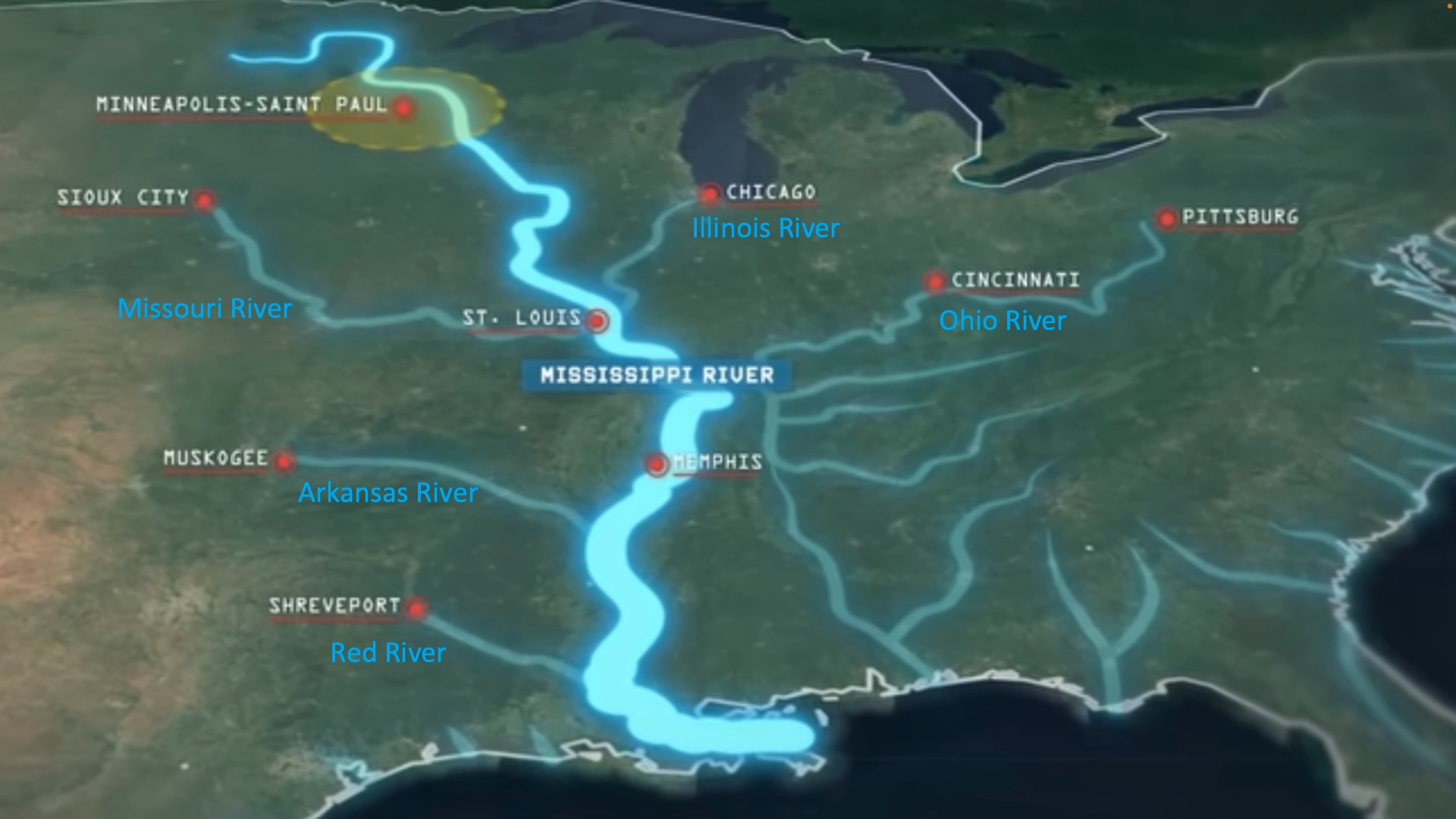
It takes 8 days for the “America Heartland” cruise between St. Louis and to St. Paul (waterfalls at the head of the Mississipi):

Cruise on a riverboat between New Orleans and Memphis, with stops in the Vicksburg battlegrounds.
on Viking or the “American Countess”.
Cruise from Chicago to St. Louis down the Illinois River.
Illinois
- Block Museum of Art at Northwestern University, Evanston
- Elmhurst Art Museum
- Krannert Art Museum, Champaign
- The Mitchell Museum and Cedarhurst Sculpture Park, Mt. Vernon
- Northern Illinois University Art Museum, DeKalb
- Rockford Art Museum
- Southern Illinois University Museum, Carbondale
- Tarble Arts Center at Eastern Illinois University, Charleston
Chicago:
Chicago had the #20 rate of crime among all cities in the US (1,099/100,000 in 2022).
- Museum of Contemporary Art (MCA), Chicago
- Art Institute of Chicago
- DePaul University Museum
- DuSable Museum of African American History
- Martin D'Arcy Museum of Art at Loyola University
- Mexican Fine Arts Center Museum
- Museum of Contemporary Art
- Museum of Contemporary Photography at Columbia College
- National Vietnam Veterans Art Museum
- Oriental Institute Museum at the University of Chicago
- Smart Museum of Art at the University of Chicago
- Ukrainian Institute of Modern Art
- Barack Obama Presidential Library, Hoffman Estates
- Farnsworth House (1951), 14520 River Road, Plano, IL 60545
- Purple Pig
- Zahav [Israeli restaurant]
- Au Cheval burgers [#29]
- Fat Rice, Chicago [#58]
- Red Apple Buffet
- Alinea (3-star Michelin & rated the Best Restaurant in the US)
Missouri
- Harry S. Truman Presidential Library and Museum, Independence
- Ashby-Hodge Gallery of American Art, Fayette
- Daum Museum of Contemporary Art, Sedalia
- Margaret Harwell Art Museum, Poplar Bluff
- Museum of Art and Archaeology at the University of Missouri, Columbia
- Mark Twain Museum, Hanibal
Kansas City:
- Albrecht-Kemper Museum of Art, St. Joseph
- Kemper Museum of Contemporary Art and Design, Kansas City
- Nelson-Atkins Museum of Art, Kansas City
St. Louis:
St. Louis had the #1 rate of crime among all cities in the US (2,082/100,000 in 2022).
- Contemporary Art Museum St. Louis
- Mildred Lane Kemper Art Museum at Washington University
- Laumeier Sculpture Park,
- Woodcock Museum,
- Pulitzer Foundation for the Arts,
- Sheldon Art Galleries,
- Saint Louis Art Museum
- Saint Louis University Museum of Art
Tennessee
- Carroll Reece Museum at East Tennessee State University, Johnson City
- Hunter Museum of American Art, Chattanooga
- Knoxville Museum of Art
- McClung Museum at the University of Tennesse, Knoxville
- Dollywood (amusement park), Pigeon Forge
- The Barn at Blackberry Farm, Walland, Tennessee
Nashville:
Nashville had the #16 rate of crime among all cities in the US (1,138/100,000 in 2022).
- Cheekwood Museum of Art, Nashville
- The Parthenon, Nashville
- Tennessee State Museum, Nashville
- Vanderbilt University Fine Arts Gallery, Nashville
Memphis:
Memphis had the #4 rate of crime among all cities in the US (2,003/100,000 in 2022).
- Art Museum of the University of Memphis
- Dixon Gallery and Gardens
- Memphis Brooks Museum of Art
- University of Memphis Institute of Egyptian Art and Archaeology
- Elvis Prestly's Graceland
- Sun Records
- Flight restaurant, Memphis
Arkansas
Little Rock had the #5 rate of crime among all cities in the US (1,634/100,000 in 2022).
- Anthony Chapel in Garvan Woodland Gardens at U of Arkansas
- Crystal Bridges Museum of American Art, Bentonville
- Ozark Heritage Arts Center and Museum, Leslie
- Baum Gallery of Fine Art at the University of Central Arkansas, Conway
- Clinton Presidential Library and Museum, Little Rock
- Toltec Mounds, Scott [site]
Mississippi
- George E. Ohr Arts and Cultural Center, Biloxi
- Lauren Rogers Museum of Art, Laurel
- Mississippi Museum of Art, Jackson
- University Museums at the University of Mississippi, Oxford
- Walter Anderson Museum of Art, Ocean Springs
Louisiana
New Orleans had the #18 rate of crime among all cities in the US (1,121/100,000 in 2022).
- Alexandria Museum of Art
- Contemporary Arts Center New Orleans
- Louisiana State Museum, New Orleans
- Mardi Gras World, New Orleans
- Louisiana State University Museum of Art, Baton Rouge
- Meadows Museum of Art at Centenary College, Shreveport
- New Orleans Museum of Art
- R.W. Norton Art Gallery, Shreveport
- Ogden Museum of Southern Art, New Orleans
- Mounds at Poverty Point
- Delgado Museum of Art
- Louisiane State Museum
Alabama
- Huntsville Museum of Art
- Birmingham Museum of Art
- Highlands Bar & Grill, Birmingham
- Montgomery Museum of Fine Arts
- Acre, Auburn
- American Sport Art Museum and Archives, Daphne
- Wiregrass Museum of Art, Dothan
- Mobile Museum of Art
Northward on Cattle Drives
The TV series “1883” is about one of the cattle drives that brought Texas back from economic collapse after the end of the Civil War in 1865. The drive went from Fort Worth North toward Montana and Portland. Although a fictional story, the script mentions real locations: Doan’s Store Red River Crossing, established 1878 along the Western Trail to Dodge City, Kansas where trains carried cattle East.
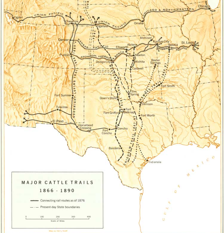
In 1881 the Doan’s Cross reached a peak of 301,000 cattle driven by to Kansas shipping points. This was before the “Chisolm Trail”.
In 1884 an annual picnic, celebrating the cattle drives and cowboy tradition, began near Doan’s Store.
In 1885 long cattle drives was eliminated by both the construction of railroads across north Texas and the fencing of the West using newly invented barbed wire.
The TV series “Lonesome Dove”, is set in late 1870s. Just like the “1883” TV series, it is also about cowboys seeking to drive cattle North to settle along Montana’s Yellowstone River. Several other movies have characters doing the same.
Journey down the Pan American Highway
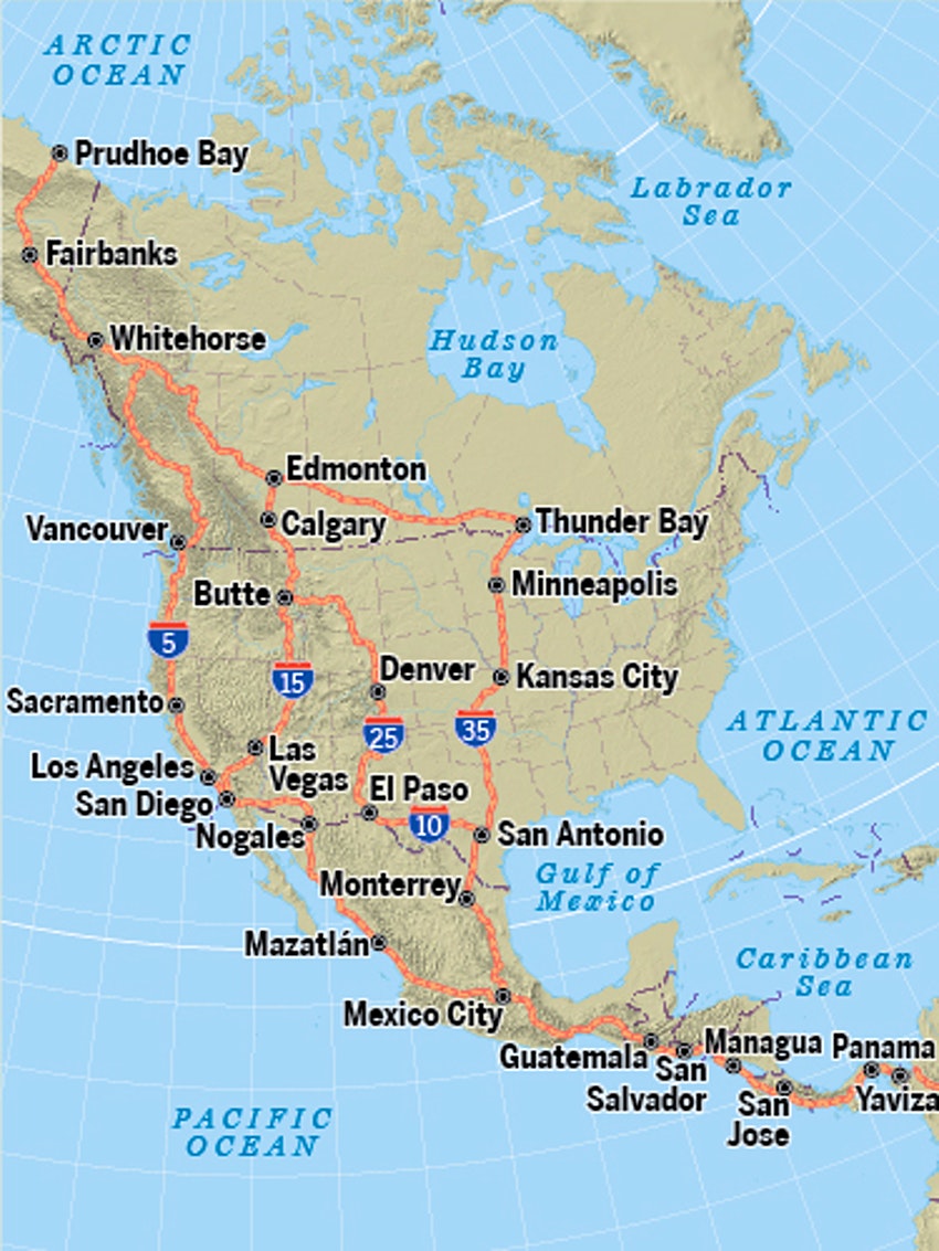 VIDEO:
The longest road in the world is the 30,000 km (19,000 miles) of the Pan American Highway.
VIDEO:
The longest road in the world is the 30,000 km (19,000 miles) of the Pan American Highway.
It starts from the North in Prudhoe Bay, Alaska through Fairbanks, into Canada’s Whitehorse, Edmonton, Calgary. It crosses into the United States down highway 15 and 87 into Billings, Montana. Then down 90, 25, into Denver. 285 into Albuquerque, New Mexico. 40 and 285 to Roswell, then 385 to Browfield. 87 to Eden. 83 to Junction. 10 to San Antonio and 85 to Loredo, Texas. 285 into Mexico to Monterrey and Mexico City.
Except for a break flying over the swamps of the Darian Gap between two continents at Yaviza, Panama and Turbo, Antioquia, Colombia, the Vía Panam or Vía Panamericana goes all the way down to Tierra del Fuego, Chile.

Westward on land
“Go West, young Man, and grow up with the country!” is the advice widely (but wrongly) attributed to New York Tribune Publisher Horace Greeley, who visited the West only once.
The Pony Express
80 Pony Express riders (who include Calamity Jane) traveled day and night to deliver mail from St. Joseph, Missouri on the Missouri River to San Francisco, California in only 10 days rather than the previous 24 days. They carried news of the volatile time leading up to the Civil War.

Photo source: Wikimedia.
The riders can run at full gallop along their 1,900-mile (3,100 km) route because they switch horses waiting at each of 184 stations, each about 10-15 miles apart.
But their service lasted for less than 2 years – from April 3, 1860 to October 24, 1861 – due to the availability of the electric telegraph along railroads.
Westward from Vermont to Kentucky
Vermont
- Bennington Museum
- Brattleboro Museum and Art Center
- Fleming Museum at the University of Vermont, Burlington
- Middlebury College Museum of Art
- Norman Rockwell Museum, Rutland Town
- St. Johnsbury Athenaeum
- Shelburne Museum
- Ark Encounter, Williamstown
Upstate New York
Albany/Rochester:
- Albany Institute of History and Art
- Castellani Art Museum at Niagara University, Niagara Falls
- George Eastman House International Museum of Photography and Film, Rochester
- Memorial Art Gallery at the University of Rochester
- Strong Museum, Rochester
- University Art Museum, Albany
Adirondacks
- The Adirondack Museum, Blue Mountain Lake
- American Museum of the Moving Image, Astoria
- Canajoharie Library and Art Gallery
- Corning Museum of Glass, Corning
- Dia: Beacon, Beacon City
- Samuel Dorsky Museum of Art at SUNY New Paltz
- Emerson Gallery at Hamilton College, Clinton
- Everson Museum of Art, Syracuse
- Fenimore Art Museum, Cooperstown
- Frederic Remington Art Museum, Ogdensburg
- Genesee Country Village and Museum, Mumford
- Guild Hall, East Hampton
- Hammond Museum and Japanese Stroll Garden, North Salem
- Heckscher Museum of Art, Huntington
- Hofstra University Museum, Hempstead
- Hudson River Museum, Yonkers
- Hyde Collection Art Museum, Glens Falls
- Isamu Noguchi Garden Museum, Long Island City
- Islip Art Museum, East Islip
- Johnson Museum of Art at Cornell University, Ithaca
- Katonah Museum of Art
- Loeb Art Center at Vassar College, Poughkeepsie
- Long Island Museum of American Art, History and Carriages, Stony Brook
- Morrisville College Library
- Nassau County Museum of Art, Roslyn Harbor
- Neuberger Museum of Art at Purchase College, Purchase
- New York State Museum, Albany
- Newington-Cropsey Foundation, Hastings on Hudson
- NY Center for Media Arts, Long Island City
- Parrish Art Museum, Southampton
- Picker Art Gallery at Colgate University, Hamilton
- Plattsburgh State University Art Museum
- P.S. 1 Museum, Long Island City
- Rockwell Museum, Corning
- Schein-Joseph International Museum of Ceramic Art, Alfred
- The Schick Art Gallery and The Tang Museum at Skidmore College, Saratoga Springs
- Shaker Museum and Library, Old Chatham
- Storm King Art Center, Mountainville
- Syracuse University Art Collection
Buffalo:
- Albright-Knox Art Gallery, Buffalo
- State University at Buffalo Art Gallery
- The Burchfield Penney Art Center, Buffalo
Michigan
- Henry Ford Museum
- Greenfield village
- Cranbrook Art Museum, Bloomfield Hills
- Dennos Museum Center, Traverse City
- Flint Institute of Arts
- Grand Rapids Art Museum
- Kelsey Museum of Archaeology at the University of Michigan, Ann Arbor
- Kresge Art Museum at Michigan State University, East Lansing
- Muskegon Museum of Art
- Saginaw Art Museum
- Shiawassee Arts Center, Owosso
- University of Michigan Museum of Art, Ann Arbor
- Urban Institute for Contemporary Arts, Grand Rapids
- Gerald R. Ford Presidential Library, Ann Arbor
Detroit
Detroit had the #2 rate of crime among all cities in the US (2,057/100,000 in 2022).
- Detroit Institute of Art</strong>
- Detroit Institute of Arts Image Database
- Lafayette vs. American Coney Island hot dogs [#97]
Ohio
- Toledo Museum of Art
- Table 128 Bistro, Toledo
Cincinnati:
- Cincinnati Art Museum
- Museum Center of Union Terminal
- American Neon Sign Museum</a>
- Creation Museum (is closest to the Cincinnati airport)
- Ark Encounter (44 miles South in Kentucky from the Creation Museum)
Cleveland:
Cleveland had the #8 rate of crime among all cities in the US (1,557/100,000 in 2022).
- Rock and Roll Hall of Fame by the Lake Erie shore
- Cleveland Museum of Art
Indiana
Indianapolis:
- Indianapolis Children's Museum
- Eiteljorg Museum of American Indians and Western Art
- Herron School of Art Gallery
- Indiana State Museum
- Indianapolis Museum of Art
- National Art Museum of Sport at Indiana University, Indianapolis
- Richmond Art Museum
- Alewife restaurant, Richmond
- Indianapolis Art Center
- Indianapolis Museum of Art
- Ball State University Museum of Art, Muncie
- Brauer Museum of Art at Valparaiso University
- Evansville Museum of Arts and Science
- Fort Wayne Museum of Art
- Greater Lafayette Museum of Art
- Greentown Glass Museum
- Indiana University Art Museum, Bloomington
- Snite Museum of Art at the University of Notre Dame, South Bend
- Swope Art Museum, Terre Haute
- Turman Gallery at Indiana State University, Terre Haute
Kentucky
- International Museum of the Horse, Lexington
- Kentucky Art and Craft Foundation, Louisville
- Kentucky Museum at Western Kentucky University, Bowling Green
- Speed Art Museum, Louisville
- University of Kentucky Art Museum, Lexington
- Mammoth Cave National Park
Down the Pacific West Coast
- The Coast Starlight line on Amtrak has coastal portions between Seattle and Portland, and along the middle of California.
Alaska
- Alaska State Museum, Juneau
- Anchorage Museum of History and Art
- University of Alaska Museum, Fairbanks
NOTE: Driving from Alaska to Washington state requires travel through Canada.
Washington
- Tacoma Art Museum
- Maryhill Museum of Art, Goldendale
- Museum of Northwest Art, La Conner
Spokane:
Seattle:
- Center on Contemporary Art
- Henry Art Gallery at the University of Washington
- Seattle Art Museum
- Wing Luke Asian Museum
- EAP Museum (Music Project rock 'n' roll museum)
Oregon
- Coos Art Museum, Coos Bay
- Corvallis Arts Center
- Hallie Ford Museum of Art at Willamette University, Salem
- Portland Art Museum
- Portland Institute for Contemporary Art
- Le Pigeon (Le Pigeon burger), Portland
- Schneider Museum of Art at Southern Oregon University, Ashland
- University of Oregon Museum of Art, Eugene
California
- Crocker Art Museum, Sacramento
- The Kitchen Restaurant, Sacramento
- Stockton - Haggin Museum
- Sonoma Valley Museum of Art, Sonoma
- Sonoma State University Art Gallery, Rohnert Park
- di Rosa Preserve, Napa
San Francisco Bay:
- Yerba Buena Center for the Arts, San Francisco
- San Francisco Museum of Modern Art
- Asian Art Museum of San Francisco
- San Francisco State University Fine Arts Gallery
- Thacher Gallery at the University of San Francisco
- California Academy of Science
- California Museum of the Legion Of Honor
- San Francisco Museum of Modern Art
- M H de Young Museum, San Francisco
- Friends of Photography/Ansel Adams Center, San Francisco
- The Jewish Museum, San Francisco</a>
- Museum of Craft and Folk Art
- Cable Car Museum
- Alcatraz island [ferry]
- Art Museum at Saint Mary's College, Moraga
- Oakland Museum of California
- Judah L. Magnes Museum, Berkeley
- Berkeley Art Museum + Pacific Film Archive at U.C. Berkeley
San Jose:
- San Jose Museum of Art
- de Saisset Museum at Santa Clara University
- Cantor Center for Visual Arts at Stanford University
- New Guinea Sculpture Garden at Stanford University
- Art-Tech (Silicon Valley Institute for Art and Technology)
- Museum Of Art And History, Santa Cruz
- Rosicrucian Egyptian Museum
- Triton Museum of Art, Santa Clara
- Hubert Julian Stowitts Museum and Library, Pacific Grove
- Monterey Museum of Art
Santa Barbara (Central Coast):
- Hearst Castle, San Simeon
- Oceanside Museum of Art
- Art Museum at U.C. Santa Barbara
- Santa Barbara Museum of Art
- Wildling Art Museum, Los Olivos
- California Center for the Arts, Escondido
- Carnegie Art Museum, Oxnard
- Lee Institute for Japanese Art, Hanford
- Ventura County Museum of History and Art, Ventura
West Side, Los Angeles:
- J. Paul Getty Museum, Malibu
- Santa Monica Museum of Art
- UCLA Fowler Museum of Cultural History, Los Angeles
- Armand Hammer Museum of Art at UCLA, Los Angeles
- Museum of Television and Radio, Beverly Hills
- Skirball Cultural Center, Los Angeles
- Los Angeles County Museum of Art, Los Angeles
- California African-American Museum, Los Angeles
- Museum of Contemporary Art
Downtown Los Angeles:
- Corita [Kent] Art Center, Los Angeles
- Museum of Neon Art, Los Angeles
- Korean American Museum, Los Angeles
- Fisher Gallery at the University of Southern California, Los Angeles
- The Broad, then Otium restaurant, downtown Los Angeles
- Southwest Museum, Los Angeles
East Los Angeles:
- Autry Museum of Western Heritage
- Ronald Reagan Presidential Library and Museum, Simi Valley
- Huntington Library, San Marino
- Norton Simon Museum, Pasadena
- Pacific Asia Museum, Pasadena
South Bay, Long Beach:
- Museum of Latin American Art, Long Beach
- Long Beach Museum of Art
- California State University Art Museum, Long Beach
- California State University Library, Long Beach
Orange County:
- Richard Nixon Presidential Library and Museum, Yorba Linda
- Fullerton Museum Center
- Disneyland, Anaheim
- Bowers Museum of Cultural Art, Santa Ana
- Irvine Museum
- Orange County Museum of Art, Newport Beach
- Laguna Art Museum, Laguna Beach
Inland Empire:
- Ruth Chandler Williamson Gallery at Scripps College, Claremont
- Pomona College Museum of Art, Claremont
- Latino Art Museum, Pomona
- Historical Glass Museum, Redlands
- California Museum of Photography at U.C. Riverside
- Sweeney Art Gallery at U.C. Riverside
- Riverside Art Museum
- Bakersfield Museum of Art
- Palm Springs Desert Museum
San Diego:
- Museum of Photographic Arts
- Mingei International Museum of Folk Art
- Timken Museum of Art, San Diego
- Museum of Contemporary Art
- San Diego Art Institute
- Stuart Collection of Sculpture at U.C. San Diego
- San Diego Museum Of Art
- Addison (restaurant), Del Mar, San Diego
Hawaii
Honolulu and Hawaii as a whole had the lowest crime rate among all US cities and states.
- Contemporary Museum, Honolulu
- Honolulu Academy of Arts
- Hana Cultural Center and Museum, Hana, Maui
Westward through Northern states
Going from New York City to Seattle takes 2,852-miles on Interstates 80 and 90, crossing 11 states.
Northern Rail
Amtrak’s Empire Builder train between Chicago to Seattle and Portland takes 46 hours.

Amtrak’s California Zephyr (named after the Greek god of the Western wind). VIDEO: from Chicago to Emeryville (San Franciso) – 2 nights through 7 states: Naperville, Galesburg, Omaha, Denver (a one hour stop) over the mountains to Grand Junction, Reno, Truckee, Salt Lake City. With no wi-fi between stations.
Lewis and Clark Trail Westward Ho
The Lewis and Clark Expedition of 1804 to 1806 is an 8,000-mile trip to the Pacific (Portland, Oregon) returned with maps and scientific specimens for President Thomas Jefferson.
The Lewis and Clark Trail today is a set of hiking trails. “Wm Clark” carved “July 25, 1806” on “Pompey’s Pillar” 30m miles East of Billings, Montana.

The “Corps of Discovery” emboldened wagon trains traveling Westward through Northern United States.
Oregon Trail to the Pacific
The Oregon Trail was established during the 1830s by mountain men in their fur trade, before motorized transportation. It favors valleys to minimize going over mountains:

The trail begins from St. Louis and Independence, Missouri through Kansas and Nebraska to Fort Laramie, Wyoming (1834-1890). It then goes through Boise, Idaho to Portland, Oregon. A map of the trail in 1907:

Kansas
- Boot Hill Museum, Dodge City
- Beach Museum of Art at Kansas State University, Manhattan
- Birger Sandzen Memorial Gallery, Lindsborg
- Coutts Memorial Museum of Art, El Dorado
- Mulvane Art Museum at Washburn University, Topeka
- Spencer Museum of Art at the University of Kansas, Lawrence
- Ulrich Museum of Art at Wichita State University
- Wichita Art Museum
- Oz museum, Wamego
Iowa
- Arts Iowa City
- Blanden Memorial Art Museum, Fort Dodge
- Brunnier Art Museum at Iowa State University, Ames
- Cedar Rapids Museum of Art
- Davenport Museum of Art
- Des Moines Art Center
- University of Iowa Museum of Art, Iowa City
- Waterloo Museum of Art
- Des Moines: Living History Farms (at Urbandale)
- Herbert Hoover Presidential Library and Museum, West Branch
- Walcott Trucking Museumis next to Iowa 80, the largest truck stop in the world (VIDEO)
Wisconsin
- Elvehjem Museum of Art at the University of Wisconsin, Madison
- Fairfield Public Gallery, Sturgeon Bay
- John Michael Kohler Arts Center, Sheboygan
- Leigh Yawkey Woodson Art Museum, Wausau
- Madison Museum of Contemporary Art
- Paine Art Center and Arboretum, Oshkosh
- Racine Art Museum
- West Bend Art Museum
- Wright Museum of Art at Beloit College, Beloit
Milwaukee:
Milwaukee had the #6 rate of crime among all cities in the US (2,082/100,000 in 2022).
- William F. Eisner Museum of Advertising and Design, Milwaukee
- Haggerty Museum of Art at Marquette University, Milwaukee
- Milwaukee Art Museum
- Ristorante Bartolotta [#94]
Minnesota
Duluth (North coast of Lake Superior)
Minneapolis:
Minneapolis had the #19 rate of crime among all cities in the US (1,101/100,000 in 2022).
- The Minneapolis Institute of Arts
- Minneapolis Institute of Arts</strong>
- Walker Art Center, Minneapolis
- Weisman Art Museum at the University of Minnesota, Minneapolis
- Spoon and Stable restaurant, Minneapolis
St. Paul:
- Denler Art Gallery at Northwestern College St. Paul
- American Museum of Asmat Art St. Paul
- Goldstein Museum of Design at the University of Minnesota St. Paul
- Minnesota Museum of American Art, St. Paul
- Green Giant statue, Blue Earth 56013 (off hwy 90)
Nebraska
- Great Plains Art Collection at the University of Nebraska, Lincoln
- Joslyn Art Museum, Omaha
- Museum of Nebraska Art at the University of Nebraska, Kearney
- Sheldon Memorial Art Gallery at the University of Nebraska, Lincoln
South Dakota
- Mount Rushmore National Memorial, Keystone
- Hotel Alex Johnson, Rapid City
- Redlin Art Center, Watertown
North Dakota
- North Dakota Museum of Art, Grand Forks
- Plains Art Museum, Fargo
- Passage to India lunch buffet, Fargo
Montana
- Holter Museum of Art, Helena
- Glacier National Park "Crown of the Continent"
- C.M. Russell Museum, Great Falls
- Art Museum of Missoula
- University of Montana Museum of Fine Arts, Missoula
- Museum of the Rockies, Bozeman
- American Computer & Robotics Museum, Bozeman
- Tippet Rise Art Center, near Bozeman
- Yellowstone Art Museum, Billings
- The only known markings by the Lewis and Clark Corp, Billings
Idaho
Westward through the Southwest
Route 66
VIDEO: Route 66 was one of the original highways within the U.S. starting in 1924. Thus its colloqual name the “Mother Road”. It served as a military transport corridor during WWII. In post-war years, motels, diners, and gas stations along Route 66 became popular vacaction destinations.

Route 66 begins on Michigan Avene in Chicago, where you can eat at Lou Mitchell’s diner. The route goes to St. Louis, Missouri, then through smaller road-side towns on the way to Tulsa and Oklahoma City, Amarillo TX, Alberquque New Mexico, then over mountains to Flagstaff AZ before ending on the Santa Monica pier in Los Angeles, California.
However, interstate freeways built from 1956 enabled travel without the need to slow down through towns. That bypassed small businesses along Route 66.
Chisolm Trail
The Chisolm Trail was used between 1867-1884 to drive cows to market from various cowtowns in Texas through Oklahoma Indian Territory to Abilene and other railheads in Kansas. The Lonesome Dove TV series depicts that time.
Since Illinos and Missouri are already listed in our Mississippi route, here we begin from Oklahoma and take a long detour North to avoid too much desert along the way.
Oklahoma
- Fred Jones Jr. Museum of Art at the University of Oklahoma, Norman
- Gilcrease Museum, Tulsa
- National Cowboy Hall of Fame and Western Heritage Museum, Oklahoma City
- Philbrook Museum of Art (Philbrook Art Centre), Tulsa
Texas
- Amarillo Museum of Art
- Cadillac Ranch near Amarillo
- Arlington Museum of Art
- Art Museum of Southeast Texas, Beaumont
- Beeville Art Museum
- Chinati Foundation, Marfa
- Cushing Memorial Library at Texas A&M University, College Station
- El Paso Museum of Art
- Grace Museum, Abilene
- Longview Museum of Fine Arts
- McNay Art Museum, San Antonio
- Museum of the Southwest, Midland
- Museum of Texas Tech University, Lubbock
- Ellen Noel Art Museum, Odessa
- San Antonio Art League Museum
- San Antonio Museum of Art
- South Texas Institute for the Arts, Corpus Christi
- Stark Museum of Art, Orange
- University of North Texas Art Galleries, Denton
Dallas:
- Crow Collection of Asian Art
- The McKinney Avenue Contemporary (MAC)
- Meadows Museum at Southern Methodist University, Dallas
- Amon Carter Museum, Fort Worth
- Dallas Museum of Art</strong>
- Kimbell Art Museum</strong>, Fort Worth
- Art Center Waco
- Modern Art Museum of Fort Worth
- Sid Richardson Collection of Western Art, Fort Worth
- Baylor University Art Galleries, Waco
- George Bush Presidential Library and Museum, College Station
- George W. Bush Presidential Library and Museum, Dallas
Austin:
- Ransom Humanities Research Center at the University of Texas, Austin
- Austin Museum of Art
- Blanton Museum of Art at the University of Texas, Austin
- Mexic-Arte Museum, Austin
- Lyndon Baines Johnson Presidential Library and Museum, Austin
Houston:
- Baker Planetarium
- Rice University Art Gallery, Houston
- Blaffer Gallery at the University of Houston
- Museum of Fine Arts</strong>, Houston
- Contemporary Arts Museum, Houston
- Museum of Medical Science
- The Contemporary Arts Museum
- Menil Collection
- The Art Car Museum
New Mexico
- Albuquerque Museum
- Millicent Rogers Museum of Northern New Mexico
- Roswell Museum and Art Center
- Carlsbad Caverns National Park
Santa Fe:
- Georgia O'Keeffe Museum
- Museum of International Folk Art
- Museum of New Mexico
- New Mexico Legislature Art Gallery
Taos:
Colorado
- Aspen Art Museum
- Boulder Museum of Contemporary Art
- Leanin' Tree Museum of Western Art, Boulder
- The Museum of Outdoor Arts, Englewood
- Hoover Dam, Boulder City
- Frasca Food & Wine, Boulder
Denver:
- Denver Museum of Art
- Denver Museum of Natural History
- Kirkland Museum, Denver
- Museo de las Americas, Denver
- Museum of Contemporary Art/Denver
Wyoming
- Buffalo Bill Historical Center, Cody
- Briton Museum, Big Horn
- University of Wyoming Art Museum, Laramie
- National Museum of Wildlife Art, Jackson Hole
(Southern Idaho)
Utah
- Brigham Young University Museum of Art, Provo
- Springville Museum of Art
- The Museum of (Mormon) Church History and Art, Salt Lake City
- Utah Museum of Fine Arts at the University of Utah, Salt Lake City
- Braithwaite Arts Gallery at Southern Utah University, Cedar City
Arizona
- El Tovar Hotel on the North Rim has a formal dress code!
- Grand Canyon Village
- Arizona State University Art Museum, Tempe
- Center for Creative Photography at the University of Arizona, Tuscon
- Desert Caballeros Western Museum, Wickenburg
- Fleischer Museum of American and Russian Impressionism, Scottsdale
- Heard Museum, Phoenix
- Museum of Northern Arizona, Flagstaff
- Phippen Art Museum, Prescott
- Phoenix Art Museum
- Scottsdale Museum of Contemporary Art
- Tucson Museum of Art
- University of Arizona Museum of Art, Tucson
- West Valley Art Museum, Surprise
- Musical Instrument Museum, Phoenix
Nevada
- Nevada Museum of Art, Reno
- Harrah's Auto Collection, Reno
All the sights
In addition to “museums”, also included here are grand natural sights:
- historic landmark hotels
- Restaurants with unique interiors/art
- Cool Architecture - churches
- National Monuments
-
US Presidential libraries, museums, and birth places
- Iconic movie locations of note [map]
- Caverns
-
Zoos
- Factory tours
-
Experiences sold by Viator, The ONE Thing You Must Do In Each U.S. State
- Amusement parks
- State Fairs
- Tripadvisor Excellence award winners
- Most scenic restaurants according to OpenTable, Zagat, Michelin
Technical Footnote
This rather large list was originally created to be intentionally large in order to test how well the system handles a large file (how quickly it can download and display).
This is an upgrade of my terrible Roadtrips to visit museums across the USA from 2005.
Next, I’d like to display a Google map of coordinates from a public Google spreadsheet like Jessica Lord’s hack-spots site implemented from a github repo which uses the sheetsee.js and Mapbox libraries.
“I haven’t been everywhere, but it’s on my list.” – Susan Sontag